
New York Film Location Maps
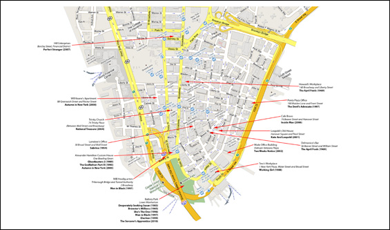
Take a tour around the streets of Manhattan with the help of these exclusive location maps from On the Set of New York.com. In upper Manhattan see the townhouse used in Panic Room, the cafe in You've Got Mail, the famous apartment buildings featured in Breakfast at Tiffany's and The Seven Year Itch. In midtown Manhattan see the apartments for 13 Going on 30 and Just My Luck, the skyscraper used in Sliver and the famous Waldorf Astoria that featured in Serendipity, Maid in Manhattan and many more. In lower Manhattan, visit the deli featured in When Harry Met Sally, the apartment building in Ghost, the bistro in No Reservations and the Ghostbusters headquarters. All these locations and many more are available on these maps. Maybe you can even find your own historic apartments for rent!
Upper Manhattan
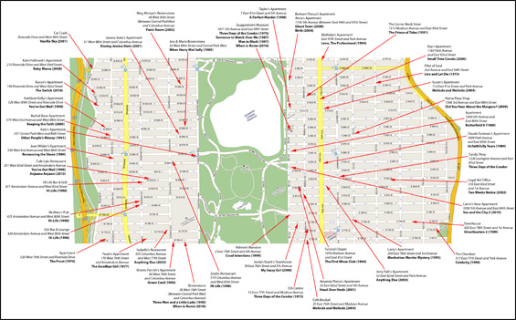
Upper Manhattan denotes the more northerly region of the New York City Borough of Manhattan. Its southern boundary may be defined anywhere between 59th Street and 155th Street. between these two extremes lies the most common definitions of Upper Manhattan as Manhattan above 96th Street (the southern boundary of Manhattan Valley in the west and Spanish Harlem in the east). The Upper West Side is more affluent than its northern neighbours such as Manhattanville, Morningside Heights, Inwood, etc. The Upper East side is similarly more affluent than its northern neighbour Spanish Harlem. All of Upper Manhattan is contained in the larger area New Yorkers know as Uptown (above 59th Street.) Many diplomatic missions are located in former mansions on the Upper East Side.

Midtown Manhattan
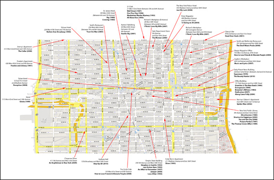
Midtown Manhattan, or simply Midtown, is an area of Manhattan, New York City home to world-famous commercial zones such as Rockefeller Center, Broadway, and Times Square. Midtown Manhattan is home to the city's tallest and most famous buildings such as the Empire State Building and Chrysler Building. As New York's largest central business district, Midtown Manhattan is indisputably the busiest single commercial district in the United States, and among the most intensely and diversely used pieces of real estate in the world. The great majority of New York City's skyscrapers, including its tallest hotels and apartment towers, lie within Midtown. More than 700,000 commuters work in its offices, hotels, and retail establishments; the area also hosts many tourists, visiting residents, and students. Some areas, especially Times Square and Fifth Avenue, have massive clusters of retail establishments. Sixth Avenue in Midtown holds the headquarters of three of the four major television networks, and is one of a few global centers of news and entertainment. It is also a growing center of finance, second in importance within the United States only to Downtown Manhattan's Financial District. Times Square is also the epicenter of American theater.
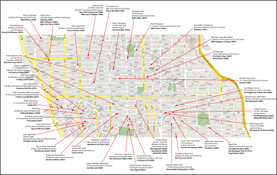
Lower Manhattan
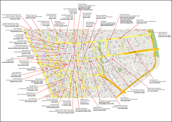
Lower Manhattan is the southernmost part of the island of Manhattan, the main island and center of business and government of the City of New York. Lower Manhattan or "downtown" is defined most commonly as the area delineated on the north by 14th Street, on the west by the Hudson River, on the east by the East River, and on the south by New York Harbour. The lower Manhattan business district forms the core of the area below Chambers Street. It includes the Financial District—often referred to as Wall Street, after its primary artery—and the site of the World Trade Center. At the island's southern tip is Battery Park; City Hall is just to the north of the Financial District. Also south of Chambers Street are the planned community of Battery Park City and the South Street Seaport historic area. The neighbourhood of TriBeCa straddles Chambers on the west side; at the street's east end is the giant Manhattan Municipal Building. North of Chambers Street and the Brooklyn Bridge and south of Canal Street lies most of New York's oldest Chinatown community. Many court buildings and other government offices are also located in this area. The Lower East Side neighborhood straddles Canal. North of Canal and south of 14th Street are the neighbourhoods of SoHo, the Meatpacking District, the West Village, Greenwich Village, Little Italy, Nolita, and the East Village. between 14th and 23rd streets are lower Chelsea, Union Square, the Flatiron District, Gramercy, and the large residential development Peter Cooper Village—Stuyvesant Town.
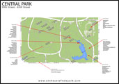
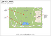
Central Park
 |
||
 |
||
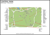
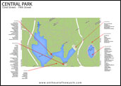
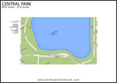
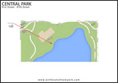
Central Park is an urban park in Manhattan in New York City. The park initially opened in 1857, on 778 acres (315 ha) of city-owned land (it is 840 acres today). In 1858, Frederick Law Olmsted and Calvert Vaux won a design competition to improve and expand the park with a plan they entitled the Greensward Plan. Construction began the same year, continued during the American Civil War, and was completed in 1873. Central Park is the most visited urban park in the United States. Designated a National Historic Landmark in 1962, the park is currently managed by the Central Park Conservancy under contract with the city government. The Conservancy is a non-profit organization that contributes 83.5% of Central Park's $37.5 million annual budget, and employs 80.7% of the park's maintenance staff.
Quick Links

Chart Listings
Disclaimer
All images that appear on the site are copyrighted to their respective owners and otsoNY.com claims no credit for them unless otherwise noted. If you own the rights to any of the images and do not wish them to appear on the site please contact us, and they will be promptly removed.
|
2009-2025 onthesetofnewyork.com | Film Locations | Picture Gallery | Privacy Policy | Disclaimer | Contact |
Donations for hosting |
|